Year Four: Repaddling the NFCT in Sections
Part 3: Map 6—The Clyde River
Instead of listing my daily trips which bounced around over the next few days, the following entries will document the Clyde River section beginning in Island Pond and ending at the Bridge Street take-out in Derby Center. I paddled and portaged the last segment upstream from Newport toward the end of this year's trip.
-----------------------------
Sunday, May 10 and Monday, May 11, 2015
Waterbury, Vt.
Hiking Break
Spent a non-paddling day in Waterbury, Vt. hiking 5.7 miles to Silver Lake in the Green Mountains, sampling some of the Otter Creek Brewery Offerings and visiting with 2014 Through-Paddler, Dan and his wife Michelle before heading back north to resume paddling the Trail to paddle the length of the Clyde downstream.
 |
| 2014 TP'er Dan Brown and I at the Swift House Inn |
-----------------------------
Map 6, Day 20: Tuesday, May 12, 2015
Island Pond, Vt. to Great Falls Carry
Miles: 19.5 (Totaling about six hours of paddling)
Portages: 0* (Only around fallen trees)
Boat: Old Town Kayak
Weather: Pouring rain in morning, partly cloudy and sunshine from late morning through evening; mid afternoon shower; wind
Wildlife: Canadian Geese, Ducks, Osprey, Hawks, Great Blue Herons, Muskrat
Overnight: Ten Mile Square Road with the camper
Cumulative section trip miles: 57
After leaving Waterbury on Monday, we headed up to Island Pond, where we first based camped at Ten Mile Square Road (by the Farm Stand) and later stayed at the Clyde River House (after the spring fisherman vacated it.)
 |
NFCT Farmstead and
Ten Mile Square Road Campsite
 |
NFCT Informational Sign
at Ten Mile Square Road
|
|
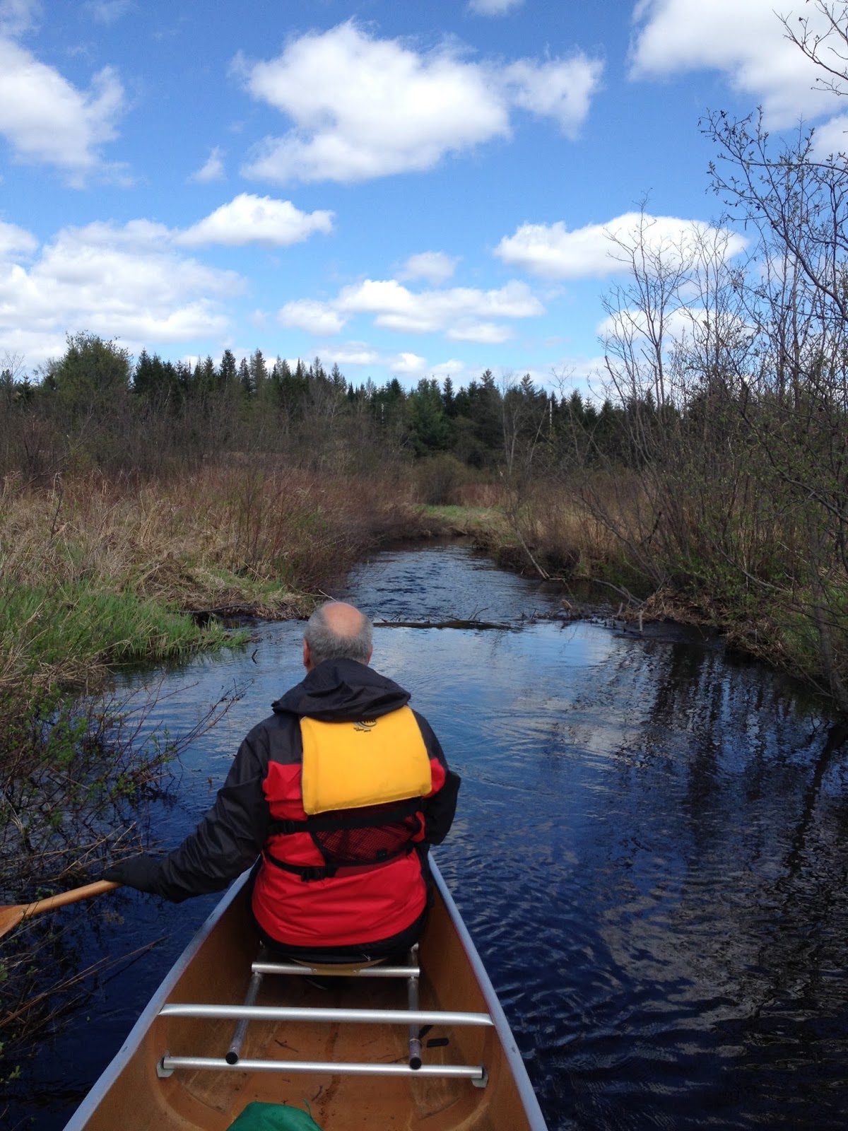
On Tuesday, we woke up to light rain and wind with gusts up to 20 mph. We headed up to Island Pond to check out the Yellow Deli, a favorite restaurant I visited two times before, but it was closed! (Hopefully only seasonally???) On our way to the boat launch, I espied a man who looked like he could be a through-paddler heading to the former Clyde River Hotel. Yup, two canoes stashed behind the lodging. There I met four men from upstate New York who started their Through-Paddler in early May. (I'm so sorry, I forgot your names!) After visiting for a short time, I headed to the Island Pond boat launch and they got ready to head east through to the Nulhegan via the pond. I launched in pouring rain. Sam headed over to the hotel to catch me paddling under it and then spent the morning at the library catching up on emails and work. Within an hour or so, the rain receded and the sun came out.
*Going downstream means I had no reason to portage around the one rapid and breached dam between Island Pond and Five Mile Square Road (the "Tubes"). Water was perfect for running the wave trains through the short rapid run and I could slide through the "V" over the breached dam. For the upstream paddler, both most likely require tracking or carrying around. I was also able to run over the beaver dams--about three of them in high water. Expect additional obstructions in low water.
 |
| Short wave train below breached dam |
 |
Rapid section between Island Pond and
Five Mile Square Road
 |
River wide fallen tree between Five Mile Square Road
and the breached dam
|
|
The only time(s) I needed to exit the kayak and carry were around one or two fallen trees.
The course of the Clyde is fairly easy to follow going downstream. After emerging from the alder thickets and narrow channel, the Clyde River House appears on the west shore adjacent to dead stand of trees and backwater along the main channel. As far as I could tell, it's the only place on the fen where electric lines are strung out over the water crossing over from Route 105 to the house.
 |
Clyde River House
(as seen when paddling downstream through
the Fen area—or looking back)
|
Like 2013, I battled headwinds going downstream through the open area after the fen to Ten Mile Square Road boat launch, where I met Sam for a quick lunch.
Back on the river, the river resumed its narrow, snaking ways. I had to carry around another large river wide fallen tree soon after leaving the boat launch, which may now have been removed. This section is sometimes used as a day trip launching point for Clyde River Recreation, although the more common departure point is at Twin Bridges Road or School Road. The river is definitely kept open from School Road to Pensioner Pond. Wind was less of an issue paddling within this stretch.
Sam met me at the Route 105 Bridge Great Falls Carry take-out/put-in.
For the upstream paddler in search of a campsite, there may be a few additional stealth camp options.
Unlike 2011, there were no riverside sandbars on which one could camp.
Between Great Falls Carry and Toad Pond, its farm fields and flood plains, not suitable for camping.
- Somewhere in the vicinity of, or shortly after, Toad Pond, but well before reaching School Road, a grassy clearing with rocks appear river right (your left), then the cedar with perhaps two camping areas. A firepit and stacked wood is apparent on a small point where a sign ironcially indicates no fires.
 |
Unofficial campsite?
(between Toad Pond and School Road)
Toad Pond to School Road: Undeveloped cedar lined river banks, might be possible for stealth camping under the cedars.
|
 |
|
| Typical scenery between Pensioner Pond and School Road |
|
Twin Bridges Road to Ten Mile Square Road: Farm fields and flood plains, not suitable for camping.
- An overgrown picnic (?) area appears about .5 miles beyond the Tubes, river left (your right). The area is accessible by a dirt track from Route 105, but is more secluded than the boat launch by the Tubes.
 |
Overgrown picnic area a few twists of the river
east of Five Mile Square Road and the Tubes
|
Five Mile Square Road to Island Pond: Undeveloped cedar lined river banks especially around the rapids area.
 |
Beaver dam near Island Pond
|
Cellphone service: Verizon doesn’t work in this area between West Charleston and Island Pond.
 |
| Departing Island Pond from the boat launch |
 |
| Emerging from under the hotel on the Clyde River |
 |
The Tubes at Five Mile Square Road
(Had enough head room to paddle through) |
 |
The reassuring "landmark" residence after getting through
the fen, just before reaching Five Mile Square Road |
 |
Clyde River opening heading toward
Five Mile Square Road after passing the Clyde River House |
 |
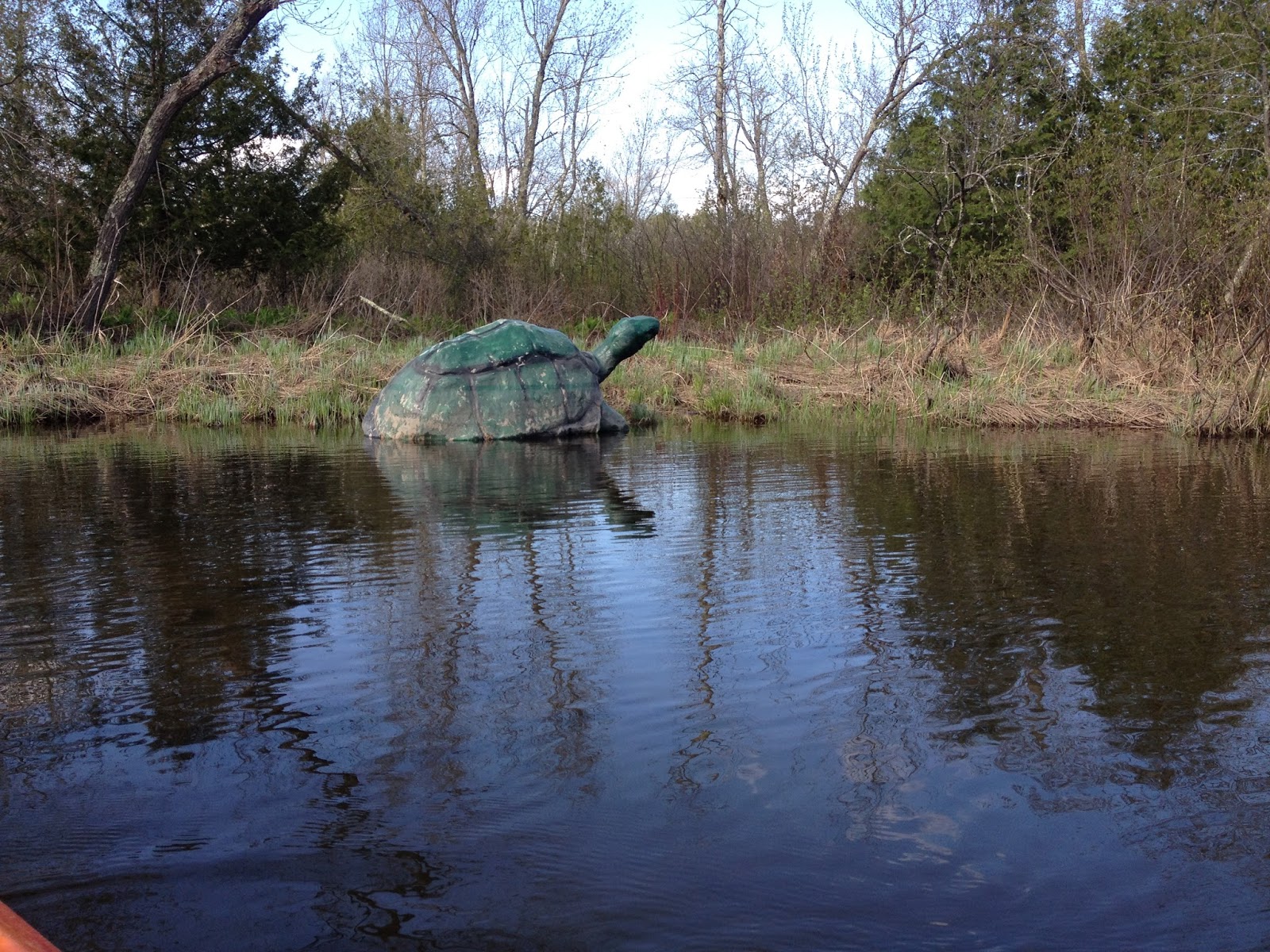
The Most Photographed Turtle on the NFCT
(Between Pensioner Pond and Toad Pond) |
-----------------------------
Map 6, Day 21: Monday, May 11, 2015
Great Falls Carry to Salem Lake
Miles: 5 (in two hours including one portage)
Portages: 1 (out of a possible two)
Boat: Old Town Kayak
Weather:
Raining, threat of thunderstorms, some thunder
Wildlife: Canadian Geese, Ducks, maybe an eagle
Overnight: Ten Mile Square Road with the camper
Cumulative section trip miles: 62
Portage(s): .6 miles through West Charleston
And here is where the descent of the Clyde becomes out of sequence. This section was paddled first upon arrival Monday back up in the Northeast Kingdom. We arrived mid-afternoon and headed first to meet up with Bill Manning at the NFCT Farm Stand at Ten Mile Square Road, where we dropped off the trailer and canoe. Then onto Clyde River Recreation, located in West Charleston to pick up a rental kayak to use for the rest of the week. It was 3:30 p.m. and I could still knock off a few miles so we headed to the put-in on Charleston Pond. Technically there is a portage between the Route 105 bridge and the put-in (or take-out) below the Great Falls Dam, but Clyde River Recreation is less than a half mile, maybe even only a quarter mile, away from the mandatory portage. We instead drove to the pond. I later paddled to the takeout as part of my 19.5 mile day from Island Pond.
The NFCT campsite on Charleston Pond is right at the access and historically has been trash-filled. The adjacent property is now posted discouraging would-be campers from moving farther away into the woods.
 |
View of Charleston Pond from Great
Falls Carry boat access (and NFCT campsite)
 |
| Charleston Pond Dam seen along Great Falls Carry |
|
Charleston Pond is picturesque. Cedars line the eastern shoreline and there appeared to be a better stealth campsite spot or two here, prior to passing the island as a through-paddler.
Portage: .6 miles
Took out and strapped on the portage wheels and walked in the rain to the Fontaine Bridge. I noticed that Durgin Street is not marked (no street sign) off of Route 105 and there are no NFCT confidence medallions pointing out the turn-off. It is the first road, left, after leaving Fontaine Road and passing by Scampi's.
Sam had been grocery shopping at Scampi's and met me on Route 105 and we confirmed an estimated pick-up time at Little Salem Lake.
All four corners around the Fountaine Road bridge are brushy and steep. Plus there is a boulder field that begins before reaching the bridge and a ledge under it. A few houses, river left, have mowed lawns extending to the river bank a short distance before reaching the bridge. I put back in here into the Class I-II rapids. Past paddlers have taken out here as well. The owners weren't around, but it is a good idea—and courtesy—to ask for permission prior to walking across their yards.
 |
Private property before reaching
Fontaine Bridge
 |
Closer look at the ledges under the Fontaine Bridge
 |
Class I-II boulder field below bridge
(as viewed from private property bordering the river)
|
|
|
The rapids made for a fun ride for a short distance (not so short if you are tracking up them). Soon the river quieted down and continued this way all the way to its outlet on Little Salem Lake. The lake was shallow with reeds growing in the middle of it.
Paddled through the narrow channel and around the point into Salem Lake. Sam drove up just as I was paddling up to the Vermont Department of Fish and Wildlife David H. Wood Memorial boat launch.
-----------------------------
Map 6, Day 22: Friday, May 17, 2015
Salem Lake to Derby Line/Bridge St. Riverside Access and
Pouty Beach Campground to Clyde Pond
Miles: 5 miles
Portages: 0
Boat: Old Town Kayak
Weather:
Sunshine, 70s
Overnight: Prouty Beach City Park with the camper the night prior.
Cumulative section trip miles: 67 miles
Sequently, the downstream trail picked up again at the Salem Lake boat launch. I, however, paddled this short section after ascending the Clyde from Prouty Beach Campground to Clyde Pond earlier in the morning.
Sam, the shuttler, brought me back to Salem Lake around 11 a.m. and I paddled across a mile or so of flatwater and picking up the river again at the west end. I knew there were Class II rapids and had reread some sectional paddling blogs about this stretch, but for some reason, I was thinking the most difficult section was between Derby Line/Bridge St. and Clyde Pond. For this reason, I had Sam meet me at Bridge Street instead of Clyde Pond. It wasn't until we had returned the kayak and were heading back to Wisconsin that I reread the guidebooks and realized I had actually paddled the more difficult section. Crap! Totally could have hit every piece of the Clyde. But instead, I erred on the side of caution and thus missed the two miles between Clyde Pond and Bridge Street. It still is a very difficult section for upstream Through-Paddlers due to the continuous sets of Class II rapids. The banks of the river at this point are cedar lined with many falling into the water that makes it very difficult, if not impossible to track from the shoreline.
Going downstream was a blast. And less worrisome in a polyethelene kayak. I again donned the spray skirt, which kept the breaking waves from filling up the cockpit. Water levels were pretty perfect. Enough water going over the tops of the boulder fields with clear lines around larger erratics. I was more worried about any strainers or widow makers this early in the year, but this section was free of those kinds of obstacles. The Northeast Kingdom Corps volunteer whom I spoke with at Clyde Pond had told me a friend of his had run this stretch the weekend prior and hadn't reported any cross-stream blowdowns.
After less than an hour, the Route 105 bridge appeared and the zig-zagging bend to the Bridge St. take-out. I was concerned about my ability to swiftly turn and eddy out by the take-out, so I scouted first and surprised Sam who was waiting with his back to me at the access point at water's edge. Once I saw the opening, I clambered back into the kayak and paddled 30 seconds more through one last set of rapids to the take-out. It was a perfect way to end this year's trip.
 |
More rapids looking downstream
(toward Western Street) from Bridge Street
boat access area |
But before that had happened, I started out my morning by departing Prouty Beach and paddling the Clyde upstream so I could walk the portage route and paddle Clyde Pond, two areas I missed in 2011 due to my paddler swap day and shuttle situation.
After breakfast, I paddled away from the campground while Sam finished packing up our camper with plans to get the car vacuumed out and gassed up in preparation for our start back home later in the afternoon. Headed under the Route 105 bridge and railroad bridge passing by many people fishing for salmon. I was able to get past the Western bridge take-out point (first portage option), but the current was too strong for me to reach the Clyde Stree bridge and official NFCT take-out. I ended up taking out by the mowed lawns—and what appeared to be a fishing trail—river left (my right) to access the bridge and portage.
 |
As far as I was able to get upstream on the
Clyde River before reaching the Clyde Street Bridge and taking out river right
|
 |
Looking upstream from the Clyde Street Bridge
Strapped on the portage wheels and started heading the mile following a fairly quiet road to Clyde Pond. You can see bits of the river (and rapids) from the road up from time to time.
|
 |
US River gauge along the Clyde, .2 miles from the
Clyde Street Bridge along Upper Clyde Street
|
Wasn't paying much attention to a barking dog until I saw the tethered pit bull atop a picnic table at the last house on the right, within site of the Hydro facililty. I stayed road left--as far away from the menace as possible, hoping it was tethered by a chain.
 |
Looking down at the Hydro Facility from the portage
along Upper Clyde Street
 |
Looking back at the house with a tethered
pit bull adjacent to the Hydro Facility
|
|
After passing the hydro entrance, the Upper Clyde Street continued to steeply climb—all the way until reaching Crawford Road.
 |
This is an uphill climb just past the Hydro
Facility driveway (and signed put-in for
downstream paddlers). MUCH steeper
than it appears.
 |
| NFCT marker near Clyde Dam |
 |
Put-in for upstream travelers on Clyde Pond
|
|
Put-in on Clyde Pond, left of the dam where a 1" wrapped rusty pipe extends into the reservoir. Paddled the short distance to the take-out and primitive camping on the upper northwest end where I ran into a high-school group who had recently built a picnic table and were finishing up with some clean-up. Their trash heap included tires, beer cans and a LazyBoy lounge chair, the latter of which we can only hope survived the elements long enough to ensure a unsuspecting weary traveler a few hours of leisurely—and with any luck—louse-free outdoor seating comfort in its final days.
More importantly, I also learned that a new paddler access-only campsite had just been completed on the east shore under pine trees. This will be an infinitely better rest stop over the Crawford Road-accessible take-out/campsite.
Sam met me at this take-out and I proceeded next up to Salem Lake (described above) to finish up this section, paddling downstream. I should have paddled right back to this take out back on Clyde Pond, thus following every navigable mile, but alas, someone did not take the time to thoroughly read the guidebooks...